
| HAZARD ALERT to all Mariners to sail 2 nautical miles distance from Home Reef. |
| GREEN Terrestrial Color Code to residents of Vava’u and Ha’apai. |
| YELLOW ACC to the Aviation Community. |
21/02/2025
This is a Public Notice on the volcanic activities at Home Reef Volcano.
Monitoring of the volcanic activity at Home Reef is ongoing, where it has observed increased thermal activity since the last report. The latest signs of this activity were detected on February 20th (Figure 1).
Images taken on February 8th show a significant crater on Home Reef (Figure 2), along with large rocks that likely resulted from the recent eruption (Figure 3). The crater has an estimated diameter of 78 meters and covers an area of approximately 4,350 square meters. The depth of the crater is estimated to be around 50 meters. Large rock fragments have been located between 65 and 75 meters from the center of the crater, with the largest measuring 14 by 15 square meters, which seemed to have been ejected or displaced during a recent crater-forming event.
The plume of smoke rising from the volcano is mostly made up of ash near the vent, transitioning to gas and steam as it rises higher into the atmosphere (Figure 2). We have also observed a noticeable turbidity in the waters surrounding the island, likely due to volcanic activity. Similar signs were recorded in images taken on February 20th (Figure 4).
The volcanic activity poses low risk to the Vava’u and Ha’apai communities. However, all mariners are advised to remain at least 2 nautical miles away from Home Reef until further notice. A hazard map is attached to guide all mariners sailing near Home Reef (Figure 5).
Home Reef is located 25 km southwest of Late Island, 22 km northeast of Lateiki (Metis Shoal) and 75 km northwest of Mo’unga’one Island at Latitude & Longitude 18.992°S & 174.775°W (Figure 6).
Continuation of monitoring is ongoing to monitor the situation closely in the coming weeks to ensure public safety. Regular assessments are vital as we track the volcanic activity and evaluate any potential risks in this unpredictable environment.
Issued by the Volcano Watch Team
Tonga Geological Services, Natural Resources Division
Ministry of Lands, Survey, Planning and Natural Resources
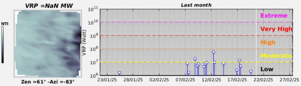
Figure 1. The VRP for Home Reef Volcano in the past 30 days (UTC time) indicates the latest thermal anomaly detected on 20th February 2025.
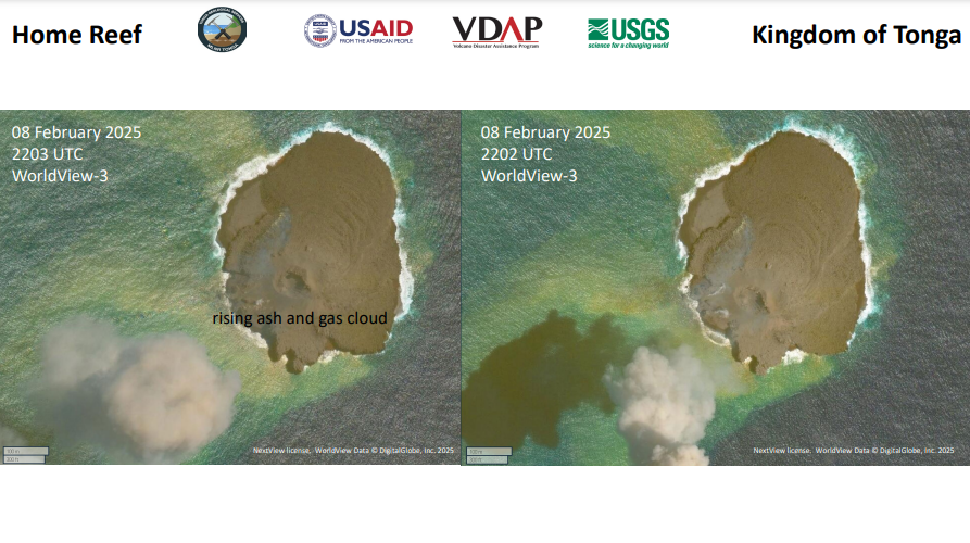
Figure 2: Satellite imagery of the volcanic island shows that the plume nearest to the vent is heavily laden with ash. As the plume rises into the atmosphere, it primarily transforms into gas and steam.
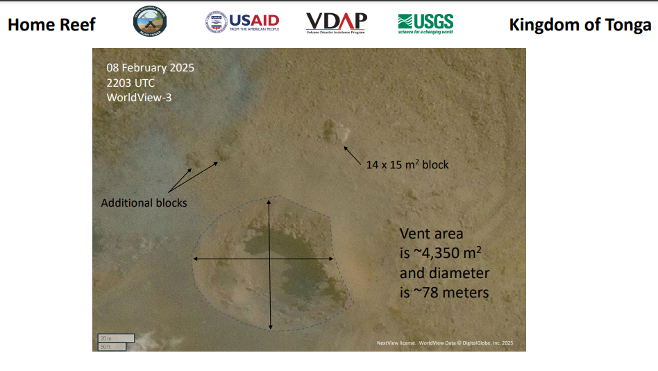
Figure 3: Recent images taken on February 8th reveal a prominent crater on Home Reef, along with large blocks that seem to have been ejected or displaced during a recent crater-forming event.
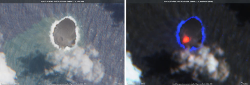
Figure 4: The February 20, 2025 image from Satellite Sentinel-2 captures significant volcanic activity, with gas and turbidity plumes visible from the sea (left). The active vent is highlighted in red (right).
Figure 5. Hazard Map/ No Go Zones of Home Reef Volcano (Based on Australia Volcano Investigations Report maps in 2008, by Dr. Paul Taylor).
Figure 6. Location Map of Home Reef.